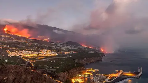
The volcanic eruption that could bring Iceland to an end

Iceland was still awaiting the deadliest volcanic eruption in half a century that threatens to completely destroy the town of Grindavík. The country is on high alert for more than 2,000 earthquakes detected in the last 48 hours, signalling the arrival of an earthquake that could change geography, on the island and globally.
At 18:00 UTC on 10 November, a 5.1 magnitude earthquake was recorded 7 km west of Grindavík. The depth was 10 km, magnitude IV on the Mercalli scale, and the seismic product was the largest of 20,000 aftershocks.
While the first consequences of earthquakes are material damage and the modification of the orography of the place, the result of those known as "superearthquakes" is different. From affecting the climate through the quantity of gases emitted or the modification of the Earth's rotational axis, to the disappearance of essential marine species in the food chain. In addition, the modification of ocean currents is one of the fears that the scientific community is most concerned about.

In Grindavík, many houses were severely damaged and roads cracked. Geophysical models show that the magmatic intrusion propagates slowly down to about 800 metres below the surface. The current symptoms are similar to those observed before the 2021 eruption of Iceland's Fagradalsfjal volcano.
The situation in the country is critical. "Since the morning of 11 November, seismic activity in the magma intrusion has been fairly constant. Since midnight on 12 November, around 1,000 earthquakes have been recorded within the boundaries of the dike, all of them with a magnitude of less than 3.0," according to the statement issued by Icelandic authorities.
The Icelandic Meteorological Office, the University of Iceland and the Department of Civil Protection and Emergency Management agree that the magma channel beneath the town of Grindavík is moving "dangerously" towards the surface. The main problem for the Reykjavík authorities is to predict when and where the magma will rise to the outside.

Iceland "land of fire and ice"
The island nation is historically one of the most seismically and volcanically active countries. Iceland's history cannot be understood without its constant earth movements and numerous volcanic eruptions.
Authorities and airlines have been taking precautions since the Eyjafjallajökull volcano erupted in 2010, disrupting airspace and blocking much of northern Europe due to ash clouds. The most likely scenario is that the magma will surface in a few days, but an Eyjafjallajökull-like explosion is also possible. This led to the cancellation of more than 100,000 flights and affected 10 million passengers.

Evacuation plan
"Due to severe seismic activity in Sundnykagigar, north of Grindavík, the chief of police has declared a state of emergency to protect citizens," the Department of Civil Protection and Emergencies said. "Earthquakes may be more significant. This series of events could trigger an explosion," the government warned.
Iceland's Meteorological Office also reported on Friday night that "there are indications that significant amounts of magma are moving in an area extending from Sundnykagigar north to Grindavík". "The amount of magma involved is much larger than that observed in the largest magma intrusion associated with the Fagradalsfjal eruption," the agency added.

As a precautionary measure, an evacuation plan was drawn up for Grindavík, a town of about 4,000 people located 3 kilometres southwest of the area where Friday's quake struck. The Civil Defence Ministry also announced that it would send Tor patrol boats to Grindavík "for safety reasons". Last Thursday, the Blue Lagoon, a tourist site near the Icelandic city famous for its geothermal springs, was closed as a precaution.